
ASSESSMENT OF SEISMIC HAZARD IN THE H�A B�NH HYDROPOWER DAM
HO�NG
QUANG VINH, PHAN TRỌNG TRỊNH,
NGUYỄN VĂN HƯƠNG, NG� VĂN LI�M,
Institute of Geological Sciences, VAST,
Abstract: Basing on
the remove sensing, geological data, geomorphologic analysis and field
observations, the authors determine the fault system which is potential on
generating earthquakes and could cause damages to the H�a B�nh hydropower dam.
It is the sublongitudinal fault system composed of fault segments located in
the central part of the eastern and the western flanks of the Quaternary H�a
B�nh - Bất Bạt Graben: the H�a B�nh 1
Fault is east-dipping, N-S trending, 4 km
long, situated in the west of the H�a B�nh Graben with the dip angle of
75-80o, and the H�a B�nh 2 is
west-dipping, N-S trending, 8.4� km long,
situated in the east of the H�a B�nh Graben, with the dip angle of 70-75o.
Thereafter, the maximum credible earthquake
(MCE) and peak ground acceleration (PGA) in the H�a B�nh hydropower dam has
been assessed. The estimated MCE of HB.1 and HB.2 is 5.6 and 6.1 respectively,
and the maximum PGA at H�a B�nh dam is 0.30 g and 0.40 g, respectively.
I. INTRODUCTION
Up to present, the Ho� B�nh hydropower dam with more than 120 m in
height is the highest dam in
II. TECTONIC SETTING
The process of collision between the
The Ho� B�nh dam zone is the regional boundary between RRFZ and � River zone (Fig. 1). Uplifting of the N-S fault system is expressed clearly by a high and average topographical elevation of more than 200 m in comparison with the southwest wing. This fault expresses clearly as an active normal fault. The clearest manifestation is expressed along eastern segments. Triangular facets are expressed clearly by the westward dip. The height of triangular facets reaches 100-120 m. Typical hung valleys prove the fast uplift of the NE wing that goes beyond erosion speed of gravel, sand, soil. The H�a B�nh N-S fault system does not extend continuously, but it is divided into short segments. Strong separation and extensive activity of fault are manifested in this segment; the fault system is divided into 2 discontinuous segments that are called by us as Ho� B�nh 1 and Ho� B�nh 2 Fault segments.
III. ACTIVE TECTONICS IN HO� B�NH AND ADJACENT AREAS
From the Landsat, Spot satellite images and DEM, we defined three N-S trending segments developed next to the Ho� B�nh dam root which generates a nearly vertical-flank graben (Figs. 3 & 4). In some localities, the graben is 2.5 km wide and filled up with alluvial-proluvial deposits of up to 70 m in thickness. The fault segment in the eastern flank is 8.4 km long, and that in the west flank is 4 km long. The distance between the latter and the dam is only 0.3-2.5 km (Fig. 2). Diverging movement of the two fault segments can be clearly observed on Spot images, Landsat images, DEM and in the field. This movement is apparently characterized by triangular facets. Results acquired from tectonophysical methods are completely consistent with the above representation: if the stress field is predominantly compressive in pre-Pliocene, it is predominated by normal extending trend in Pliocene-Quaternary.
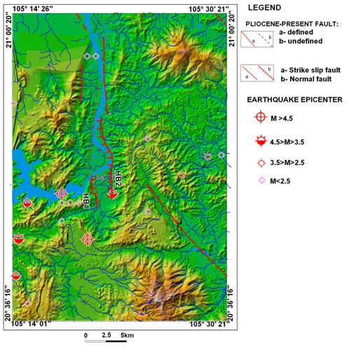
We identified the fault systems which are potential for generating earthquakes and could cause direct damages to the Ho� B�nh dam that is the sublongitudinal fault system which is well developed in this area. They also consist of segments focusing on in the central part of the eastern and the western flanks of the Quaternary Ho� B�nh - Bất Bạt Graben, on the Kim B�i Dome and on the Tu L� arc-uplifting massif. Excepting faults controlling the Ho� B�nh - Bất Bạt Graben have the length of more than 10 km, other faults often are less than 10 km long (Figs. 3� & 4).
Figure
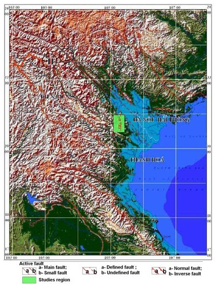
1. Sketch of active faults in North Việt
Figure
2. Active fault system in Ho� B�nh and
adjacent areas based on DEM made from topographic map at 1/50,000 scale.
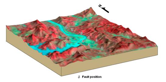
Figure 3. Stereo model of Landsat image showing the
active fault system occurring near the Ho� B�nh hydropower dam and adjacent
areas.

Figure 4. Stereo model of Spot panchromatic image showing the active fault system occurring near the Ho� B�nh hydropower dam and adjacent areas.
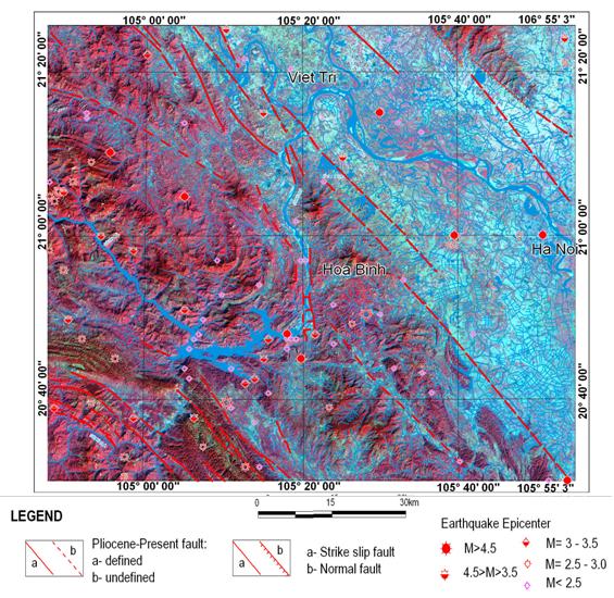
Figure 5. Active
fault systems in Ho� B�nh and adjacent areas on Landsat satellite image.
Figure
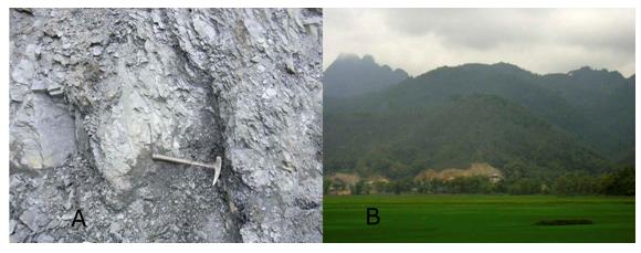
6. A: Active shear surface system cutting
across the bedding plane system in Triassic siltstones in the �ng Tượng
Hill area, Ho� B�nh City (shear surface, slickensides and bedding plane of E-W
trend and nearly vertical slope angles) filled up with black-grey or
yellow-brown or red-brown clay materials; B: Triangular facets of a normal
fault in east B�i Y�n, Ho� B�nh.
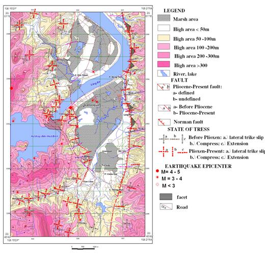
Figure 7. Sketch map of neotectonics - active geodynamics in Ho� B�nh at 1/25,000 scale.
In the contemporaneous tectonic framework, this is the youngest fault cutting and varying all older structures and former framework. On each flank of the Ho� B�nh - Bất Bạt Graben, the normal fault planes are nearly vertical, dipped to the graben centre, and each fault coincides with some landforms and controls the distribution of river terraces and alluvial flat (Fig. 5).
In general view, all of the regions belonging to the SW part of the RRFZ, Quaternary grabens and tectonic breccia zones developed close to the Red River Fault with acute angle exhibit right lateral movement regime of the RRFZ itself during Late Cenozoic.
The sublongitudinal fault system is distributed along the two flanks and controls the structure of the Ho� B�nh graben. The western fault branch running across the �ng Tượng Hill area is more than 4 km long, with the fault plane dipping eastward. Along this segment, it can be recognized a number of normal active shear zones which could cause surface cracks in this area. The eastern fault branch consists of one segment whose length is about 8.4 km (Fig. 2). Along this segment, it is strongly developed triangular facets characterizing for normal faulting. In addition, active shear zone system in the Dốc Cun area is also well identified. The fault controls the river flow and stream system according to different base levels.
Fault systems can be seen clearly on satellite images and actual topography through fault scarps, relief and facets. Remarkably, along some segments in the east of the Ho� B�nh depression, we have been identifying a series of triangular facets in L�ng Ng�i and L�ng S� areas (Fig. 6B). These facets have a height of 70-120 m and the width of foot side of more than 500 m. The age of facets must be in range of Pliocene-Quaternary that was formed by the destruction of the early Miocene peneplain. Along some segments in the west of the Ho� B�nh depression, such as in the �ng Tượng Hill area, in mafic effusive formation exposed in the west of Ho� B�nh Dam or Dốc Cun area, Ho� B�nh City, the active shear zones are of normal slip form, and its shear surfaces are concordant with the zone trend. Rolling materials consist of clay, debris of ferro-gel in fine-soft-porous state, and in some sites they can be considered as slickensides. Clearest in �ng Tượng hill area, the active shear zones cut across 20-50 m-wide bedding plane system (bedding plane of E-W trend, slope angle of 75-80o) filled up with black grey clay materials (Fig. 6A).
Faulting of branches in the east of the Ho� B�nh Depression caused landslide, fissure crack in 1996 in the �ng Tượng hill area damaging severely buildings and water supply plan of this locality. In addition, in the Dốc Cun area or in low hill range situated in the east of the Ho� B�nh dam similar normal shear zones also appear with the scale sometimes reaching up to 60-80 cm.
Geochemical anomalies: Radon and
mercury investigations show that these gas anomalies are relatively high
characterizing for activity of the active sublongitudinal fault system. The Ho�
B�nh Graben cuts across the
It is widened in 2.5 km and extends 40 km in length,
according to the sublongitudinal trend from Ho� B�nh to Bất Bạt
(Fig. 7). The Ho� B�nh graben is filled up with formations of alluvio-colluvial
pebble, gravel, sand and a little of marshy facies in the south of
IV. SEISMOTECTONIC ASSESSMENT IN HO� B�NH AND ADJACENT AREAS
In order to assess seismic hazards for Ho� B�nh
hydropower dam area, we focus on the fault systems of significant size. The
sublongitudinal fault system is distributed along two flanks. The western fault
branch is more than 4 km long with nearly vertical fault plane dipping to the
east. The shortest distance from the section Ho� B�nh 1 to Ho� B�nh dam is of
0.3 km, the fault dip is determined as 750. The eastern fault branch
is one segment of 8.4 km in length. The shortest distance from the section Ho�
B�nh 2 to the Ho� B�nh dam is of 2.5 km, the fault dip is determined as 700.
For seismic assessment, we estimate firstly the Maximum Credible Earthquake
(MCE). From MCE and distance from the fault to the hydropower dam, we estimate
the Peak Ground Acceleration.� We use
different methods to estimate MCE basing on fault length, fault area and
seismic moment.� We take the coefficient
1 for fault length approach, coefficient 2 for rupture area approach, and
coefficient 3 for earthquake moment approach. For estimating PGA, we use the
attenuation models 1, 2, 3, 4 of
Table 1. MCE
and maximum PGA at Ho� B�nh dam provoked by the segments Ho� B�nh 1� and Ho� B�nh 2.
|
No |
Fault segment |
Length (km) |
Depth (km) |
Dip |
Character |
Magnitude��
(MCE) |
Maximum PGA(g) |
|
1 |
HB1 |
4.0 |
6.0 |
75o |
|
5.6 |
0.30 |
|
3 |
HB2 |
8.4 |
6.0 |
70o |
|
6.1 |
0.40 |
V. CONCLUSIONS
Basing on the satellite interpretation and geomorphologic observation, we recognize that the N-S active fault systems are potential for generating earthquakes and could cause damages to the Ho� B�nh hydropower dam. These fault system consist of two fault segments: the first segment is east-dipping, 4 km long, with the dip angle of 75-80o, and the second is 8.4 km long, dipping westward with an angle of 70-75o. The fault segment HB1 could produce the Maximum Credible Earthquake of 5.6 and Peak Ground Acceleration at Ho� B�nh hydropower dam of 0.3 g. The fault segment HB2 could produce the Maximum Credible Earthquake of 6.1 and PGA at Ho� B�nh dam of 0.4 g.
Despite all changes the magnitude is always less than the maximum design earthquake that has been assessed (>7.5 Richter degree). For more detail, we need realize geophysical investigations and do trenching along fault segments for having geological evidences. The stress modeling of Coulomb stress change is necessary to forecast the displacement and stress distribution in depth and on the surface.
REFERENCES
1. Lacassin R., P. Tapponnier,
H.Ph. Leloup, Phan Trong Trinh, Nguyen Trong Yem, 1994. Morphotectonic
evidence for active movement along the Red River Fault zone. Proc. Intern. Seism. Haz. South.
2. Leloup H.Ph., R. Lacassin, P.
Tapponnier, U. Scharer, Zhong Dalai, Liu Xaohan, Zhang Shan, Ji Shaocheng and
Phan Trong Trinh, 1995. The Ailao Shan - Red River shear zone (
3. Nguyễn Đ�nh Xuy�n,
1985. Earthquakes in Việt
4. Nguyễn Trọng� Y�m, Phan�
Trọng� Trịnh,� Ph�ng�
Văn Ph�ch, 1991. Geological structure and� stress�
field of H�a B�nh region and its surrounding areas. Proc. 2 Conf. on Geology of
5. Phan Trong Trinh, 1995. Influence des failles actives sur les r�servoires de Hoa Binh et
Song� Chay (North Việt Nam). T�l�d�t. des Res. en eau. Press de
l'Universit� des Francofones, Qu�bec, p.
31-42.
6. Winter Th.,� Phan Trong Trinh,� R. Lacassin,�
Nguyen Trong Yem,� J. Costaz,� 1994. Advantage of a deterministic
approach of seismic risk for dam design: The Ho� B�nh dam case� (Việt